Library Catalog
Latest Documents and Publications listed. Use search terms in the box below to find what you need
Status of river breakages along the Juba and Shabelle Rivers in Somalia – February 2022
Three consecutive poor rainy seasons within the Juba and Shabelle River basins inside Somalia and the Ethiopian highlands have led to the current serious hydrological drought along the two rivers. The river levels in the upper sections are currently at their historical minimum, while the mid and lower sections of the Shabelle River having run dry. With no rains expected in February and most of March, the river flow will continue to decline.
The reduced river flow along the two rivers has negatively impacted agriculture production, domestic and livestock water use. This has also led to an increase of new river breakages as the riverine communities attempt to extract the limited resource to support livelihood activities.
SWALIM has completed analysis and mapping of the river breakages along the two rivers using very high resolution satellite images acquired thanks to the kind contribution of the Embassy of France. The study has identified 101 open points along the Shabelle, out of which 24 points are new and the rest have remained open since the last survey in August 2021. Along the Juba River, 35 open points were identified out of which 5 are new points. During this drought period, it is expected that the riverine communities will continue to extract water from the rivers by breaching the banks and this will only see an increase of the open river bank points.
Several other weak points which are not necessarily open but have the potential to overflow or break were identified during the analysis. This information is available in the SWALIM Flood Risk and Response Information Management System (http://frrims.faoswalim.org/rivers/breakages).
It is worth noting that since the last survey in August 2021, several agencies including FAO have made efforts to close about 23 of the open river banks and reinforced about 37 of weak river embankments that could otherwise flood when river levels rise.
With the Gu rains expected in April 2022, the rise in river levels will consequently lead to floods resulting from the existing open river bank points and weak river embankments. It is therefore advisable to close the open points and reinforce the weak points before the start of the Gu season to avoid the negative impacts of riverine flooding.
The methodology heavily relied on satellite imageries with limited field verification. Open breakages might have been omitted in some cases due to cloud cover or vegetation cover along the embankments
Publication Type:
Map
Publication Date:
Author:
Corporate Author:
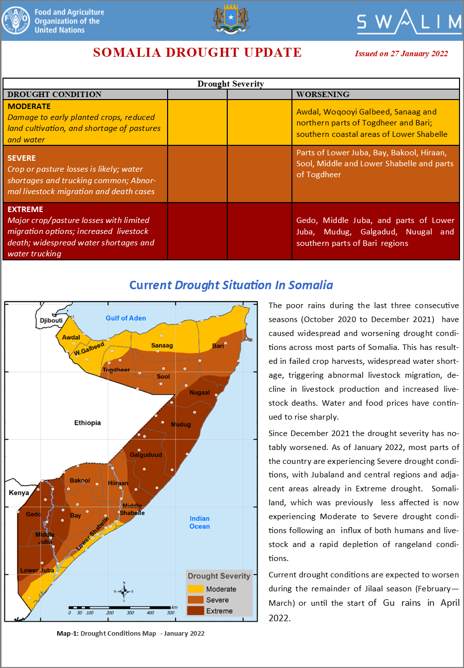
Somalia Drought Update - Issued 27 January 2022
The poor rains during the last three consecutive seasons (October 2020 to December 2021) have caused widespread and worsening drought conditions across most parts of Somalia. This has resulted in failed crop harvests, widespread water shortage, triggering abnormal livestock migration, decline in livestock production and increased livestock deaths. Water and food prices have continued to rise sharply.
Since December 2021 the drought severity has notably worsened. As of January 2022, most parts of the country are experiencing Severe drought conditions, with Jubaland and central regions and adjacent areas already in Extreme drought. Somaliland, which was previously less affected is now experiencing Moderate to Severe drought conditions following an influx of both humans and livestock and a rapid depletion of rangeland conditions.
Publication Type:
Drought watch
Publication Date:
Author:
Corporate Author:
Somalia Drought Update – Issued 22 December 2021
Drought severity in Somalia has continued to worsen following prolonged dry period characterized by high temperatures.
The drought conditions in Jubaland in southern parts of the country have deteriorated from severe to extreme. Other areas that were experiencing mild drought conditions in the north are now facing moderate levels of drought with the situation expected to get worse.
Wells are drying up rapidly while the river levels along the Juba and Shabelle continue to decrease at an alarming rate.
Currently, more than 90 percent of the country is experiencing drought conditions at different severity magnitudes with the southern and central parts being worst affected.
Pasture and water came to a complete depletion in many areas leaving about 169,000 in displacement as of today (OCHA—2022 Drought Response Plan Report).
Drought conditions are expected to worsen during the first quarter of 2022 with possibility of extending to the second quarter due to extended impacts.
Publication Type:
Drought watch
Publication Date:
Author:
Corporate Author:
Somalia Drought Update – Issued 18 November 2021
The impacts of Climate Change and variability in Somalia are the major causes of current climatic hazards that have been facing the country over the last 10 years. In 2018 and 2019 the country experienced heavy rains leading to massive flooding and associated negative impacts. This was followed by poor rains in Dyer 2020, Gu 2021 and the ongoing Deyr season.
Currently, more than 80% of the country is experiencing severe drought conditions following a third consecutive failed rainfall season. This has led to serious human suffering.
Water trucking, migration of populations and livestock has become rampant in many areas leading to quick depletion of the limited resources.
The Juba and Shabelle river levels are low and are expected to decrease further in the coming months. Likewise, most berkads and shallow wells have dried up leaving the communities to rely on boreholes which are far apart and some with low yield and poor quality especially in Puntland and the central regions.
With crop failure expected in most of the agricultural areas the prospects for Deyr season cereal production remain bleak.
The rainfall forecast for the second half of November indicates depressed rains in the country which will not be effective in mitigating the drought conditions.
Drought conditions are expected to worsen in December 2021 and the first quarter of 2022 leading to a similar situation witnessed in 2017.
Publication Type:
Drought watch
Publication Date:
Author:
Corporate Author:
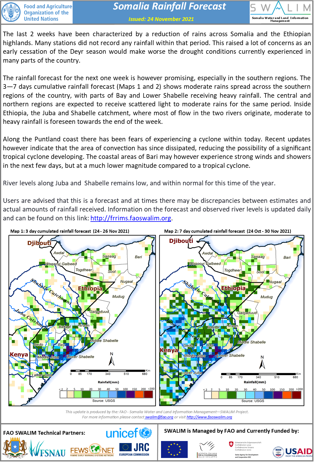
Somalia Rainfall Forecast – Issued 24 November 2021
The last 2 weeks have been characterized by a reduction of rains across Somalia and the Ethiopian highlands. Many stations did not record any rainfall within that period. This raised a lot of concerns as an early cessation of the Deyr season would make worse the drought conditions currently experienced in many parts of the country.
The rainfall forecast for the next one week is however promising, especially in the southern regions. The 3—7 days cumulative rainfall forecast (Maps 1 and 2) shows moderate rains spread across the southern regions of the country, with parts of Bay and Lower Shabelle receiving heavy rainfall. The central and northern regions are expected to receive scattered light to moderate rains for the same period. Inside Ethiopia, the Juba and Shabelle catchment, where most of flow in the two rivers originate, moderate to heavy rainfall is foreseen towards the end of the week.
Along the Puntland coast there has been fears of experiencing a cyclone within today. Recent updates however indicate that the area of convection has since dissipated, reducing the possibility of a significant tropical cyclone developing. The coastal areas of Bari may however experience strong winds and showers in the next few days, but at a much lower magnitude compared to a tropical cyclone.
River levels along Juba and Shabelle remains low, and within normal for this time of the year.
Publication Type:
Rainfall Forecast
Publication Date:
Author:
Corporate Author:
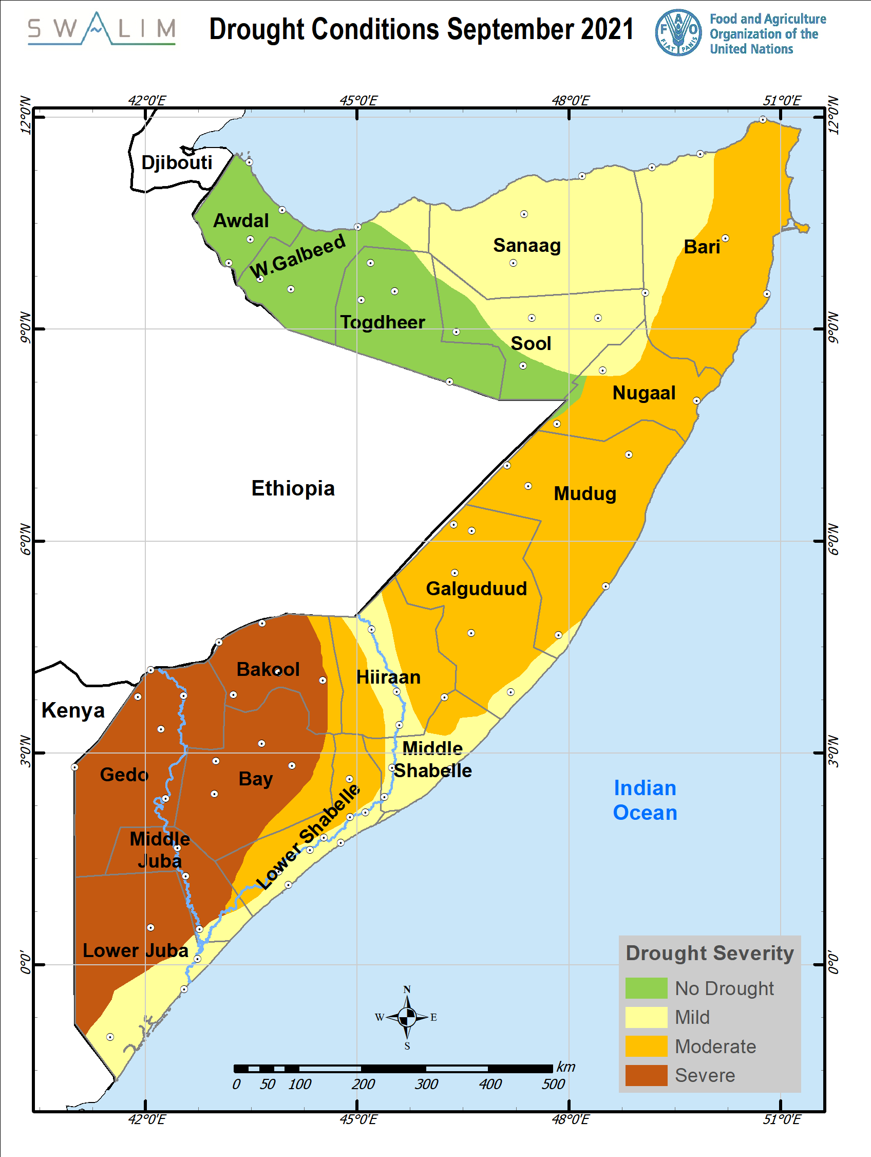
Somalia Drought Update – Issued 18 October 2021
The Deyr 2021 rains kicked off in parts of Somalia with moderate rains being observed in Puntland ( Bari region) and a few pockets in the southern regions. However, more than half of the country is still experiencing serious drought conditions.
The Southern parts of the country that had remained in moderate drought conditions in the previous months are now facing moderate to severe drought due to further depletion of the limited resources in the areas. This has led to serious human suffering and livestock death.
Drought impacts are worse in Jubaland, Southwest state, GalMudug ( central regions) and parts of Puntland which have suffered from consecutive seasons of poor rainfall. Water resources and pasture conditions have deteriorated in these areas triggering livestock migration and increased competition among pastoralists on the already limited resources.
The rainfall forecast for the second half of October indicates depressed rains in the south and central regions while the northern regions will record within normal rains. In November, the will subside in the northern areas and increase in the southern areas.
Further, the Deyr 2021 seasonal rainfall is expected to be cumulatively below average in many parts of Somalia according to ICPAC.
Given the rainfall forecast, the depressed rains are not going to be effective in mitigating the drought conditions
A return to normal rainfall patterns and in good amounts is necessary for drought conditions to be reversed. Short and intensive rains are not effective in mitigating the drought conditions, as they trigger floods (damaging the crops and washing away the upper fertile layer of soil) but does not give enough time for the water to infiltrate in the ground and improve crop germination and development.
Publication Type:
Drought watch
Publication Date:
Author:
Corporate Author:
Somalia Rainfall Forecast – Issued 28 October 2021
The Deyr seasonal rains continued to spread in across Somalia over the last week although the amounts were low. There was notably a significant reduction of rainfall amounts in Puntland and Somaliland over the same period. Further, it is worrying to note that many parts of the southern regions which are facing serious drought conditions, have not yet received the much awaited seasonal rains.
The cumulative rainfall forecast for the next seven days shows continuous spread of the Deyr rains with light to moderate intensities in parts of the northern regions, Hirshabelle, Bay and Bakool regions. Most of the central and Jubaland regions will receive minimal rains during the forecast period. In the Ethiopian highlands, whose rainfall is largely responsible for increase in river flow along the Juba and Shabelle Rivers inside Somalia, light to moderate rainfall is foreseen in the coming one week.
River levels along the upper reaches of both Juba and Shabelle continued to increase over the last one week. The levels are however within the normal for this period of the year. The increasing trend will continue given the rainfall forecast with no risk of flooding over the next seven days.
Users are advised that this is a forecast and at times there may be discrepancies between estimates and actual amounts of rainfall received. Information on the forecast and observed river levels is updated daily and can be found on this link: http://frrims.faoswalim.org.
Publication Type:
Rainfall Forecast
Publication Date:
Author:
Corporate Author:
Somalia Rainfall Forecast – Issued 04 October 2021
The 2021 Deyr rains have kicked off in parts of Somalia. The northern regions of Somaliland and Puntland recorded moderate amounts of rainfall during the last one week. Notably, Baran station in Sanaag region recorded a total of 230 mm over the last one week while Las Canood received 76 mm during the same period. The rains are expected to continue spreading in time and space during this month.
Most parts of Somaliland recorded good rains during the months of August and September.
The cumulative rainfall forecast for this week indicates significant spread of the rains within the northern parts of the country. The central and southern parts of the country will remain dry during the forecast period with the rains expected to start in the second half of October. In the Ethiopian highlands, whose rainfall is largely responsible for increase in river flow along the Juba and Shabelle Rivers inside Somalia, moderate to high rainfall is foreseen in the coming one week.
It is worth noting that, the foreseen rains in the coming week are not sufficient to alleviate the current drought conditions in the country, more rains with good temporal and spatial distribution are required during the season in order to improve the situation.
River levels along the upper reaches of both Juba and Shabelle increased over the last few days, but remains within the normal for this period of the year. Given the rainfall forecast, a slight increase in the levels for both rivers is expected with no risk of flooding over the next seven days.
Publication Type:
Rainfall Forecast
Publication Date:
Author:
Corporate Author:
Somalia Rainfall Forecast – Issued 11 October 2021
Moderate to heavy rains were observed in parts of Puntland during the last few two days. The good rains came as an immediate relief to the drought stricken areas following the failure of two consecutive rainy seasons. More rains will however be required to alleviate the water stress in Puntland and other parts of the country. On the negative side, the heavy rains led to flashfloods and consequently, loss of property and livestock death in Bari region.
The cumulative rainfall forecast for the next seven days shows continuous spread of the Deyr rains in the central and southern areas of the country. There will be a reduction of rainfall activities in Somaliland and most parts of Puntland with an exception of Nugaal region that will see moderate rains within the week. In the Ethiopian highlands, whose rainfall is largely responsible for increase in river flow along the Juba and Shabelle Rivers inside Somalia, moderate to high rainfall is foreseen in the coming one week.
River levels along the upper reaches of both Juba and Shabelle continued to increase since the last update last week. The levels are however within the normal for this period of the year. The increasing trend will continue given the rainfall forecast with no risk of flooding over the next seven days.
Publication Type:
Rainfall Forecast
Publication Date:
Author:
Corporate Author:
Flood Update for Jowhar District – Issued 16 August 2021
Observed levels of the Shabelle River in Somalia have been rising for the past two weeks. This has been attributed to moderate rains in the upper parts of the Ethiopian highlands. Currently, river levels at the upper reaches inside Somalia (Hiraan Region at Belet Weyne and Bulo Burti), are slightly above the normal range, while the mid and lower reaches (Middle and Lower Shabelle regions) are significantly above the normal levels at this time of the year. This has resulted in over bank spillage leading to riverine floods in parts Middle Shabelle. Further, two open river breakages in Jowhar district located in Bodale and Halgan village which are 22 km and 8 km south of Jowhar town respectively, have led to massive flooding in the area since 14 August 2021. According to field reports, several households have been affected and hundreds of crop destroyed.
The rainfall forecast for the coming week (16 to 22 Aug 2021) is pointing towards moderate rains within the upper parts of the Ethiopian highlands. Given the forecast, river levels are expected to continue rising further in the coming week .
Therefore, the flooding in Jowhar is high likely to be sustained throughout the week. Other areas to watch include riverine towns in the lower Shabelle region. Preliminary results from analysis of current status of river breakages along the Shabelle River by SWALIM indicate that there are several open and weak points and this could further exacerbate the flood situation. An updated database of the river breakages will be shared within a week.
Publication Type:
Flood watch bulletin
Publication Date:
Author:
Corporate Author:
Pages
 RSS feed [compliant with the Agris AP] |
  Agris AP XML


