Library Catalog
Latest Documents and Publications listed. Use search terms in the box below to find what you need
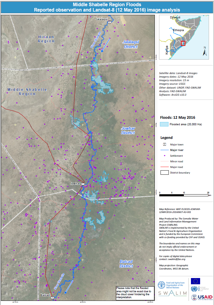
Daadadka Gobolka Shabeellaha Dhexe oo looga warbixiyay jeedaalinta iyo falanqaynta muuqaal sawirka
Xog ururin taan si toos ah ayaa looqoray iyadoo digital ah oo laga soo tafsiiray sawirka Landsat -8 iyo 12-kii May 2016 si loo muujiyo xadka bedka fatahaadda ay ka gaartey Jowhar. Fadlan la soco in laga yaabaa in aagga daadadku uusan sax ahayn sababta oo ah fasiraadda waxaa caqabadeeyey dedka daruurta.
Publication Type:
Map
Publication Date:
Author:
Corporate Author:
Sida uu noqday Roobka Gu 2016 gudaha Soomaaliya
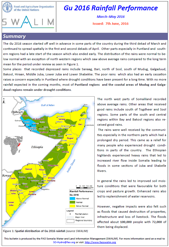
Xilligii Gu'ga 2016 wuxuu si fiican uga bilawday goor hore qaybo ka mid ah dalka, gaar ahaan Soomaaliland, intii lagu jirey tobankii maalmood ee saddexaad ee bisha Maarso oo sii socday isagoo bed ahaan faafay intii lagu jirey tobanaadkii koowaad iyo labaad ee bisha Abriil. Qaybaha kale gaar ahaan gudaha Puntland iyo gobollada koonfureed wuxuu xilligu ka bilawday goor danbe kaas oo hadana dhamaaday goor hore.
Publication Type:
Rainfall Performance
Publication Date:
Author:
Corporate Author:
Belet Weyne flood map - June 2016
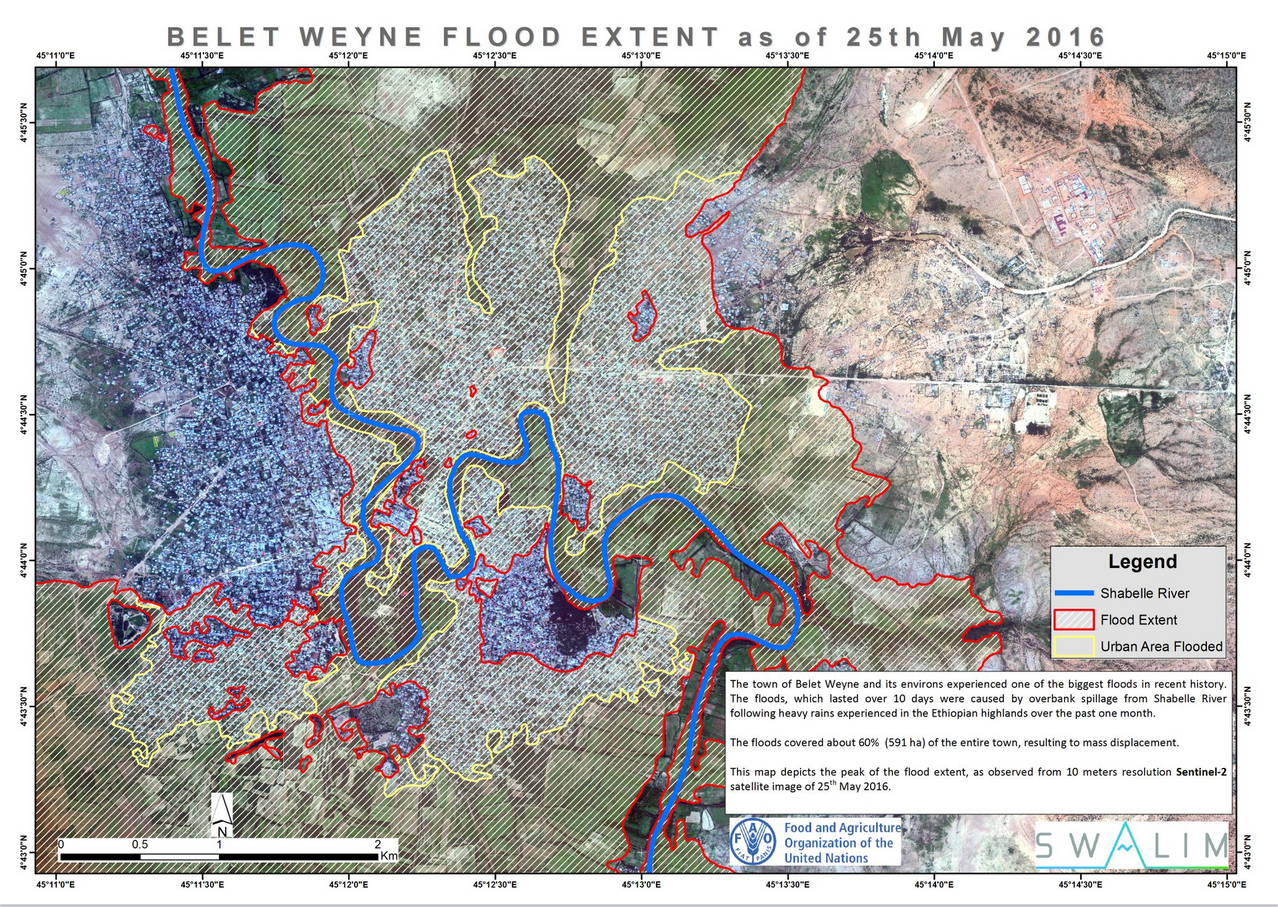
The town of Belet Weyne and its environs experienced one of the biggest floods in recent history. The floods, which lasted over 10 days were caused by overbank spillage from Shabelle River following heavy rains experienced in the Ethiopian highlands over the past one month. The floods covered about 60% (591 ha) of the entire town, resulting to mass displacement. This map depicts the peak of the flood extent, as observed from 10 meters resolution Sentinel-2 satellite image of 25th May 2016
Publication Type:
Map
Publication Date:
Author:
Corporate Author:
SWALIM Update Issue 11
We are pleased to share Issue 11 of our newsletter “SWALIM Update” for the period January 2016 – April 2016.
Publication Type:
Newsletter
Publication Date:
Author:
Corporate Author:
Somali Gu 2016 Rainfall Performance
The Gu 2016 season started off well in advance in some parts of the country during the third dekad of March and continued to spread spatially in the first and second dekads of April. Other parts especially in Puntland and southern regions had a late start of the season which also ended early. The distribution of the rains were normal to below normal with an exception of north western regions which saw above average rains compared to the long termmean for the period under review.
Some places that recorded depressed rains include Sanaag, Bari, north of Sool, south of Mudug, Galgaduud, Bakool, Hiraan, Middle Juba, Lower Juba and Lower Shabekke. The poor rains which also had an early cessation raises a concern especially in Puntland where drought conditions have been present for a long time. With no more rainfall expected in the coming months, most of Puntland regions and the coastal areas of Mudug and Galgaduud regions remain under drought conditions.
The north west parts of Somaliland recorded above average rains. Other areas that received good rains include south of Togdheer and Sool regions. Some parts of the south and central regions within Bay and Bakool regions also received good rains. The rains were well received by the communities especially in the northern parts which had a prolonged dry period. This came as a relief for many people who experienced drought conditions in parts of the country. The Ethiopian highlands experienced heavy rains that led to increased river flow inside Somalia leading to floods in some sections of Juba and Shabelle Rivers.
In general the rains led to improved soil moisture conditions that were favourable for both crops and pasture growth. Enhanced rains also led to replenishment of water reservoirs. However, negative impacts were also felt such as floods that caused destruction of properties, infrastructure and loss of livestock. The floods affected about 100,000 people with 72,000 of them being displaced.
Publication Type:
Rainfall Performance
Publication Date:
Author:
Muchiri P.
Corporate Author:
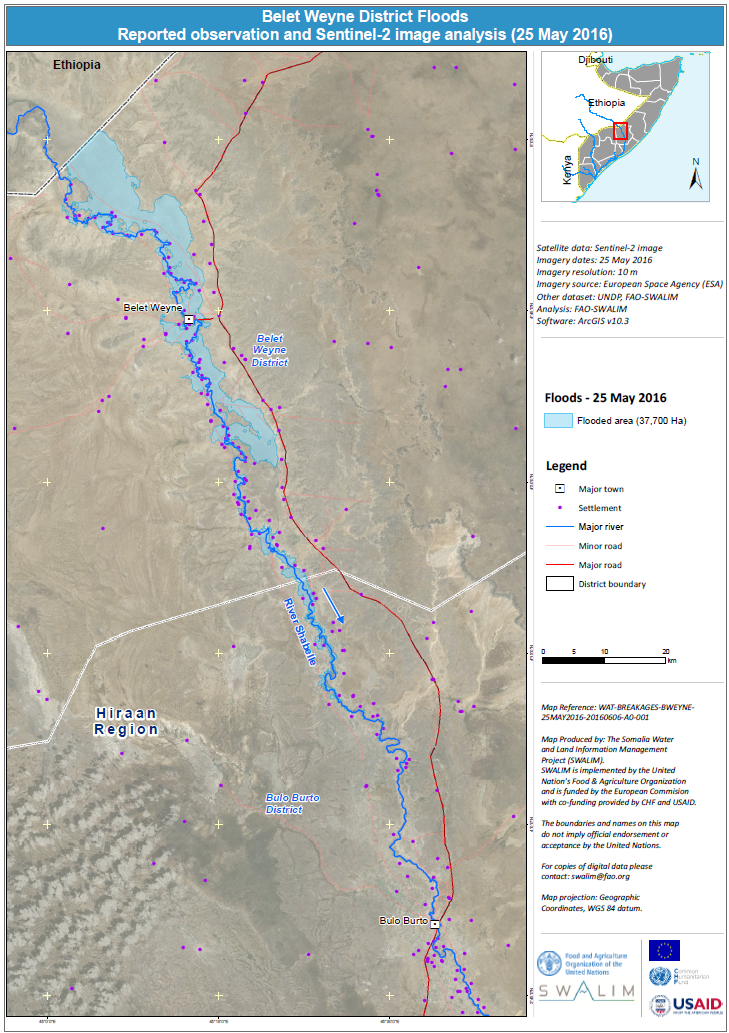
Belet Weyne District Reported Floods observation and Sentinel-2 image analysis (25 May 2016)
This dataset was digitized directly from Sentinel-2 imagery of 25th May 2016 to show the areal extent of Belet Weyne flooding. Sentinel-2 image resolution of 10m was downloaded free of charge from European Space Agency (ESA)
Publication Type:
Map
Publication Date:
Author:
Corporate Author:
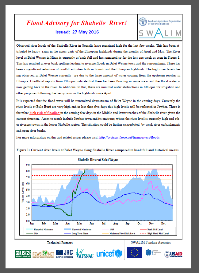
Shabelle River Flood Advisory 27-05-2016
Observed river levels of the Shabelle River in Somalia have remained high for the last few weeks. This has been attributed to heavy rains in the upper parts of the Ethiopian highlands during the months of April and May. The River level at Belet Weyne in Hiran is currently at bank full and has remained so for the last one week as seen in Figure 1. This has resulted in over bank spillage leading to riverine floods in Belet Weyne town and the surroundings. There has been a significant reduction of rainfall activities both in Somali and the Ethiopian highlands. The high river levels being observed in Belet Weyne currently are due to the large amount of water coming from the upstream reaches in Ethiopia. Unofficial reports from Ethiopia indicate that there has been flooding in some areas and the flood water is now getting back to the river. In additional to this, there are minimal water abstractions in Ethiopia for irrigation and other purposes following the heavy rains in the highlands since April.
It is expected that the flood wave will be transmitted downstream of Belet Weyne in the coming days. Currently the river levels at Bulo Burti are very high and in less than five days this high levels will be reflected in Jowhar. There is therefore high risk of flooding in the coming few days in the Middle and lower reaches of the Shabelle river given the current situation. Areas to watch include Jowhar town and its environs; where the river level is currently high and other riverine towns in the lower Shabelle region. The situation could be further exacerbated by weak river embankments and open river banks.
For more information on this and related issues please visit: http://systems.faoso.net/frrims/rivers/floods
Publication Type:
Flood Alert
Publication Date:
Author:
Corporate Author:
Somalia Rainfall Forecast 04-05-2016
Wet conditions are expected to persist across Somalia in the next three days. The northern regions of the country are expected to receive moderate to high rains, while in the central and southern regions the forecast points towards light to moderate rains.
The upper catchments of the Juba and Shabelle rivers are also expected to receive moderate to high rains within the same period. Given the forecast and the rising levels, there remains a high risk of flooding along the Middle and Lower Shabelle; while in Middle and Lower Juba the risk of flooding is remains moderate.
Publication Type:
Rainfall Forecast
Publication Date:
Author:
Corporate Author:
Somalia Rainfall Forecast 17-05-2016
Light rains are expected in a few pockets of central and northern regions in Somalia in the coming three days. The rest of the country is expected to remain dry within the same period.
There still remains a high risk of flooding along the Juba and Shabelle Rivers owing to the high river levels and existing open and weak river banks.
Publication Type:
Rainfall Forecast
Publication Date:
Author:
Corporate Author:
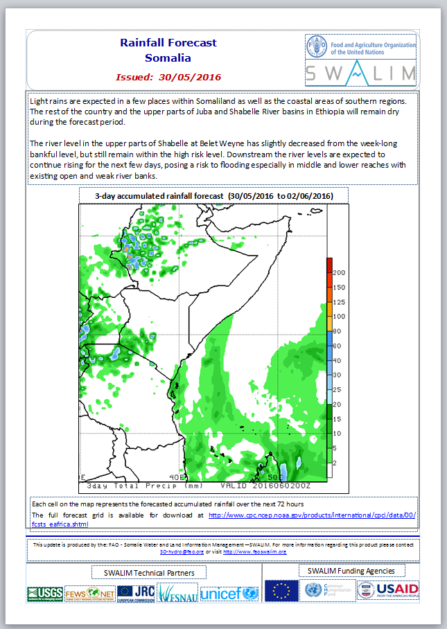
Somalia Rainfall Forecast 30-05-2016
Light rains are expected in a few places within Somaliland as well as the coastal areas of southern regions. The rest of the country and the upper parts of Juba and Shabelle River basins in Ethiopia will remain dry during the forecast period.
The river level in the upper parts of Shabelle at Belet Weyne has slightly decreased from the week-long bankful level, but still remain within the high risk level. Downstream the river levels are expected to continue rising for the next few days, posing a risk to flooding especially in middle and lower reaches with existing open and weak river banks.
Publication Type:
Rainfall Forecast
Publication Date:
Author:
Corporate Author:
Pages
 RSS feed [compliant with the Agris AP] |
  Agris AP XML


